- Home Page /
- Books /
- Science & Math /
- Earth Sciences /
- Geography /
- National Geographic Britain and Ireland Wall ...

Item #:
46401859
National Geographic Britain and Ireland Wall Map - Classic - Laminated (23.5 x 30.25 in) (National Geographic Reference Map) Map November 9, 2016
Item #:
46401859
MVR 665
Price Details
Excluding Shipping & Custom charges ( Shipping and custom charges will be calculated on checkout )
*All items will import from US
0 ratings
Write a review
In stock
QTY:
Order now and get it around Sunday, June 28
Secured transaction
Ubuy works hard to protect your security and privacy. Our advanced payment security system ensures confidentiality by encrypting your information during transmission using AES (Advanced Encryption Standards) and SSL (Secure Socket Layer) protocols. Your payment details are 100% secure as we do not share your payment details with third party sellers.
Our Top Logistics Partners
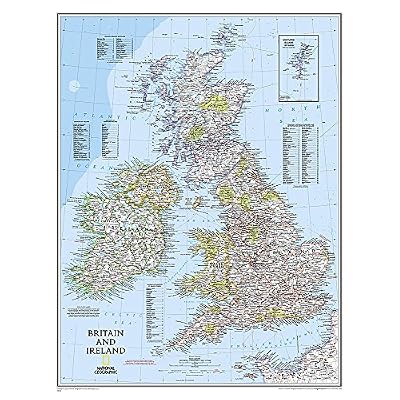
National Geographic's Classic political map of Britain and Ireland is both an attractive addition to any study or classroom and an informative tool for exploring these fascinating countries.
Fast
Shipping
Free
Return*
Secure Packaging
100% Original Products
PCI DSS Compliance

ISO 27001 Certified
Note: Step Down Voltage Transformer required for using electronics products of US store (110-120). Recommended power converters Buy Now.


What Stands Out
Detailed Cartography
This wall map features comprehensive and clear cartography, showcasing intricate details of Britain and Ireland, making it an invaluable resource for geography enthusiasts, travelers, and educators.
Laminated Finish
The laminated surface ensures durability and resistance to wear, allowing for easy cleaning and lasting use, ideal for classrooms or homes where longevity and maintenance ease are essential.
Classic Design
With a timeless aesthetic, this classic map enhances any room's décor while providing a stylish and informative visual reference, perfect for inspiring wanderlust and educating about geopolitics.
Product Details
| Item Weight | 1 lbs (450 grams) |
Who Should Buy?

-
Travel Enthusiasts
Ideal for travelers planning trips to Britain and Ireland, providing detailed geographic insights and landmarks.
-
Educators
Useful for teachers and students in geography classes to study the layout and features of these regions.
-
Home Decor
Great for decorative purposes, fits nicely in homes or offices, enhancing aesthetic appeal with its detailed design.

-
Digital Users
Not suitable for those who prefer digital maps on smartphones or tablets for navigation and interactivity.
-
High-Detail Requirements
Not appropriate for users needing highly detailed topographic or specialized maps for professional use.
-
Budget-Conscious
May not be ideal for individuals seeking low-cost or free mapping alternatives for casual use.
Product Description
National Geographic Britain and Ireland Wall Map - Classic - Laminated (23.5 x 30.25 in) (National Geographic Reference Map) Map November 9, 2016
Have any Query? Chat with us
Customer Questions & Answers
-
Question:
What are the dimensions of the National Geographic: Britain and Maldives Classic Wall Map?
Answer: The National Geographic: Britain and Maldives Classic Wall Map measures 23.5 x 30.25 inches. This size is ideal for display in a variety of settings, including classrooms, offices, or home environments. Its dimensions provide a clear and comprehensive view of Britain and Maldives, making it a perfect learning tool for geography enthusiasts or travelers planning their next adventure. -
Question:
Is the National Geographic: Britain and Maldives Classic Wall Map laminated?
Answer: Yes, this map is laminated, which enhances its durability and allows for easy handling. The lamination makes it resistant to wear and tear, making it suitable for display in high-traffic areas. It also enables users to write on the map using dry-erase markers, which can be especially useful for marking travel routes or destinations during planning sessions. -
Question:
Where can I buy the National Geographic: Britain and Maldives Classic Wall Map?
Answer: You can purchase the National Geographic: Britain and Maldives Classic Wall Map on Ubuy in Maldives. Ubuy offers a convenient platform for shopping, with various options to have this beautifully designed map delivered directly to your door, enabling you to explore and display the geography of Britain and Maldives. -
Question:
What features does the National Geographic: Britain and Maldives Classic Wall Map include?
Answer: This classic wall map features detailed geographical information, including major cities, road networks, and physical characteristics such as mountains and rivers. The map’s vibrant colors and clear labeling enhance visibility, making it not only a decorative item but also a functional reference tool for educational purposes or travel planning. -
Question:
Can the National Geographic: Britain and Maldives Classic Wall Map be used for educational purposes?
Answer: Absolutely! This map is an excellent educational resource for schools, libraries, and home study environments. Teachers and students can utilize it to learn about geographical boundaries, historical routes, and major landmarks. Its detailed and accurate representation makes it a valuable tool for enhancing geography lessons in a visual and interactive manner. -
Question:
Is this map suitable for framing?
Answer: Yes, the National Geographic: Britain and Maldives Classic Wall Map can be framed. Its laminated surface not only ensures durability but also allows it to fit seamlessly within a standard or custom frame. Framing the map can enhance your décor while protecting it from dust and damage, allowing you to showcase your interest in geography elegantly. -
Question:
What type of paper is the National Geographic: Britain and Maldives Classic Wall Map made of?
Answer: The map is printed on high-quality, durable paper that is designed to withstand frequent use. This ensures that the map remains vibrant and clear over time. The quality of the paper, combined with the lamination, makes it a great choice for environments where it may be handled often, such as classrooms or tourist information centers. -
Question:
Can I write on the laminated surface of the wall map?
Answer: Yes, the laminated surface of the National Geographic: Britain and Maldives Classic Wall Map allows you to write on it with dry-erase markers. This feature is particularly useful for specific applications, like planning trips or plotting out routes and points of interest. Simply wipe it clean after use, and the map is ready for your next planning session. -
Question:
What colors are featured on the National Geographic: Britain and Maldives Classic Wall Map?
Answer: The map boasts vibrant, colorful representations of the geographical features across Britain and Maldives. The use of distinct colors helps differentiate between various regions, cities, and natural landmarks, making it both visually appealing and very functional. Such visual clarity aids in understanding the geographic distinctions and is ideal for educational and decorative uses alike. -
Question:
Is this map an accurate representation of Britain and Maldives?
Answer: Yes, the National Geographic: Britain and Maldives Classic Wall Map is renowned for its accuracy and detail. It provides an up-to-date representation of geographical features, populations, and infrastructures. National Geographic maps are trusted for their meticulous research and high standards, making this map a reliable reference for travelers, students, and anyone interested in the geography of these regions.
Geography Editorial Review
The National Geographic Britain and Ireland Classic Wall Map is a beautifully detailed and laminated map that is suitable for framing. It is large in size and easy to read, making it very useful in trip planning. However, it is difficult to find a frame for, and there have been issues with receiving the wrong map. There is no index for finding cities, and instead only an alphabetical one for counties. Although it provides a nicely laminated overview of Great Britain, it may not be useful for reference and locating cities. Despite this, it is perfect for trip planning, with enough cities and roads shown to easily plan a route.
Customer Reviews & Ratings
1 customers ratings
-
5 Star
100%
-
4 Star
0%
-
3 Star
0%
-
2 Star
0%
-
1 Star
0%
Review this product
Share your thoughts with other customers
Pros
- Beautifully detailed and laminated
- Large size and easy to read
- Useful in trip planning
- Perfect for trip planning, with enough cities and roads shown to easily plan a route
Cons
- Difficult to find a frame for
Product Price History
Important information
- Limitations : For products shipped internationally, please note that any manufacturer warranty may not be valid; manufacturer service options may not be available; product manuals, instructions, and safety warnings may not be in destination country languages; the products (and accompanying materials) may not be designed in accordance with destination country standards, specifications, and labeling requirements; and the products may not conform to destination country voltage and other electrical standards (requiring use of an adapter or converter if appropriate). The recipient is responsible for assuring that the product can be lawfully imported to the destination country. When ordering from Ubuy or its affiliates, the recipient is the importer of record and must comply with all laws and regulations of the destination country.
- Not all the products listed on Ubuy are for sale, as Ubuy is a global search engine. Products are subject to export/trade regulations.
MVR 665
Order now and get it around Sunday, June 28
This item is not restrict in my country.(Please click on above link if this item is not restrict in your country, So our team will review and allow.)
QTY:
Secured transaction
Ubuy works hard to protect your security and privacy. Our advanced payment security system ensures confidentiality by encrypting your information during transmission using AES (Advanced Encryption Standards) and SSL (Secure Socket Layer) protocols. Your payment details are 100% secure as we do not share your payment details with third party sellers.
Our Top Logistics Partners
Fastest cross-border delivery
Features & Benefits
- Classic political map by National Geographic.
- Perfect for study, classroom, or as a decorative piece.
- Detailed with thousands of place names and major routes.
- Includes indexes for easy identification of regions.
- Laminated for durability and easy framing.
- Reveals varied topography through shaded relief.